A NATIONAL TREASURE THREATENED
| UTAH'S REDROCK WILDERNESS:
A NATIONAL TREASURE THREATENED |
"WE STAND AT A FORK IN THE ROAD. ONE ROAD OFFERS FULL PROTECTION OF THE WILDLANDS THAT WE LOVE. THE OTHER ROAD GIVES US WHAT THE UTAH CONGRESSIONAL DELEGATION DIDN'T WANT ANYWAY...THE REAL BOTTOM LINE IS THE DIVERSITY AND HEALTH OF THE WORLD BEFORE US."
- Tom Lyon, Utah citizen
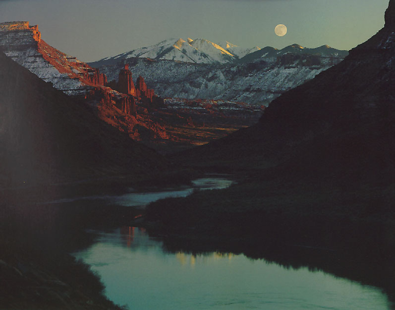
Fisher Towers, Fisher Towers and Sierra La Sal Mountains under full moon; Colorado River in foreground. © JOHN GEORGE | LA SAL CANYONS. The uplifted landscape surrounding the 11,000 foot-high peaks of the Sierra La Sal has been deeply incised by the 1,500 foot-deep canyons of the Colorado and Dolores rivers, plus numerous smaller canyon systems carved through colorful sandstone formations by streams flowing out of the mountains. Slickrock fins, domes, natural arches and bridges are abundant here, as they are within nearby Arches National Park. H.R.1745/S.884 would omit six of ten roadless areas in the La Sal region--over 60 percent of the proposed La Sal Canyons Wilderness. Development threats include uranium and oil exploration, mineral-related road construction, and a proliferation of off-road vehicle abuse and industrial tourism facilities along existing and future road corridors. |
Slide Show Menu | BWZ Table of Contents | The Battle for the Utah Wilderness | What You Can Do
Content © 1995 Southern Utah Wilderness Alliance (SUWA)

| Disclaimer . ©Copyright 1995, 1996, Better World Publishing All rights reserved. Better WorldSM and BWZ are Service Marks of Better World Publishing Questions and comments? | 
|