A NATIONAL TREASURE THREATENED
| UTAH'S REDROCK WILDERNESS:
A NATIONAL TREASURE THREATENED |
"I'M NOT A MEMBER OF ANY OF THE ENVIRONMENTAL ORGANIZATIONS AND HAVE NEVER BEEN ACTIVE IN THIS SORT OF THING IN THE PAST. BUT WHEN I REALIZED THAT THE GOVERNOR AND MEMBERS OF THE UTAH DELEGATION WERE NOT LISTENING TO WHAT THE PUBLIC SAID THEY WANTED, AND HAD MADE UP THEIR MINDS BEFORE THE HEARINGS, I FELT I HAD TO GET INVOLVED."
- Betsy Tipps, Utah citizen
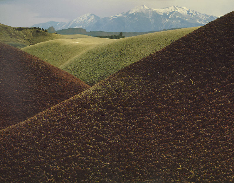
Mt. Pennell, Retonite clay hills west of Big Thompson Mesa. © JOHN GEORGE | HENRY MOUNTAINS. The last mountain range in the lower 48 states to be explored, mapped, and named, the remote Henry Mountains feature forestclad, 11,000-foot peaks surrounded by rugged mesas, canyons, and badlands. Streams rising among the high peaks flow out into the desert below, providing critical riparian habitat for wildlife. H.R.1745/S.884 would omit from wilderness protection over two-thirds of the roadless land in the region, leaving more than 240,000 acres open for proposed mineral and agricultural developments. These include coal mining on up to 100,000 acres, strip mining of up to 20,000 acres, and vast "chaining" projects which would destroy thousands of acres of pinyon juniper forest. All such development would be readily visible from vantage points within nearby Capitol Reef. |
Slide Show Menu | BWZ Table of Contents | The Battle for the Utah Wilderness | What You Can Do
Content © 1995 Southern Utah Wilderness Alliance (SUWA)

| Disclaimer . ©Copyright 1995, 1996, Better World Publishing All rights reserved. Better WorldSM and BWZ are Service Marks of Better World Publishing Questions and comments? | 
|